Home About Services Soil Investigation & Testing Pile Testing Topographic Survey Geotechnical Instrumentation Structural Testing (NDT) Environmental Site Assessment Geotechnical Design Civil & Structural Design Articles View all → ASTM Standards for Soil Boring Thai Foundation Regulation 2023 Interpreting SPT N-values Pile Testing Methods Explained Soil Bearing Capacity Careers Contact · Request a quote
Topographic and Engineering Survey

Topographic Survey in Thailand: GPS RTK, Drone, LiDAR and Bathymetric

SPN’s survey service covers ground survey and coordinate survey, drone and LiDAR, bathymetric survey, and earthwork volumes and setting out. We deliver AutoCAD files, orthophotos, point clouds and survey reports signed by a licensed engineer. We work nationwide across Thailand from our office in Bang Sao Thong, Samut Prakan, near Bangkok.
  • Engineering team with over 20 years of experience
  • 500+ projects nationwide
  • Nationwide: all 77 provinces
  • Reports signed by a licensed engineer
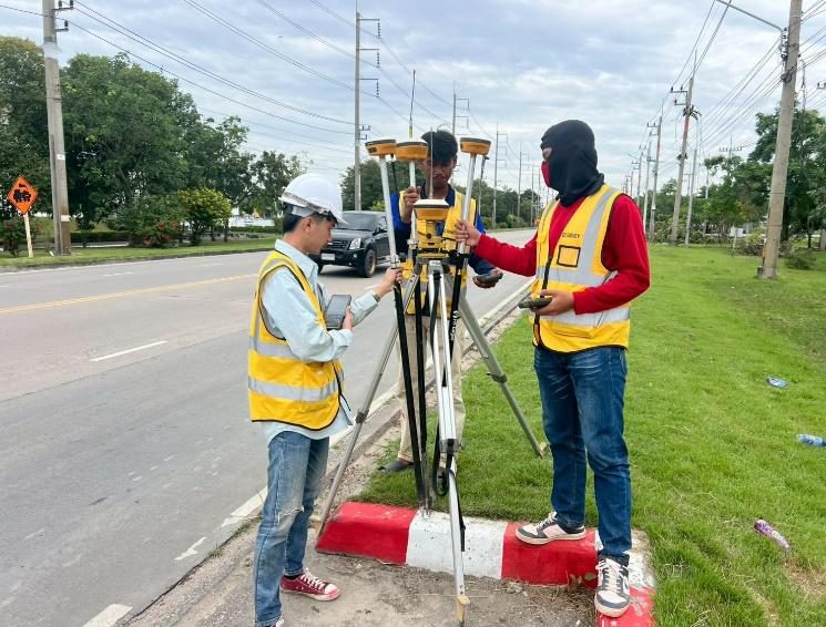
SPN survey engineer in a high-visibility vest measuring with a GPS RTK (GNSS rover) on a project site

Service overview: topographic and engineering survey

A topographic survey measures the position, elevation and shape of a site to produce maps and drawings for design and construction. SPN chooses the method to suit the site size, accuracy and budget: GPS RTK and Total Station for detailed work, drones and LiDAR for large areas, and depth sounding for rivers, coasts and reservoirs. SPN does not carry out cadastral or land-boundary surveys.

Scope

What it covers

  • Ground: GPS RTK · Total Station · precise levelling · as-built · utilities
  • Aerial: drone photogrammetry · LiDAR · thermal / multispectral
  • Water: single-beam · multibeam · side-scan sonar
  • Cut and fill · stockpile volumes · borehole setting out
When to use

When you need it

  • Before designing buildings, factories, roads and solar farms
  • Calculating cut, fill and stockpile volumes
  • Tracking construction progress by drone
  • Surveying rivers, coasts and reservoir volumes
Deliverables

What you receive

  • Topographic maps and contours (DWG · DXF · PDF)
  • Orthophoto, DSM/DTM and point cloud (LAS)
  • Earthwork volume reports, profiles and cross-sections
  • Survey report signed by a licensed engineer

Ground survey and setting out

Ground surveys give the highest accuracy and form the base for design and construction; SPN uses GPS RTK in open areas and Total Station where satellite signals are blocked, tied to one control network.

  • GPS RTK Topographic SurveyContour map and spot levels across the site, accurate to ±1–3 cm (about ±1–2 cm horizontal, ±2–3 cm vertical), in WGS84 or Indian 1975 (UTM Zone 47N/48N). Suited to large open sites.
  • Total Station SurveyCoordinates and levels to ±5 mm with Topcon SDR. Used in urban areas, factories and places where buildings or trees block satellite signals, for buildings, road alignments and utility lines.
  • Control Point and Benchmark SurveyA network of control points and benchmarks so the project uses one coordinate set from survey through design to construction. Delivered with a coordinate list, photos and a location plan.
  • Precise Levelling and Deformation SurveyLevelling with an automatic level and staff, transferring MSL heights from reference benchmarks. Repeat rounds track settlement or movement of buildings, roads and embankments, alongside SPN instrumentation work.
  • Route and Cross-section SurveyAlignment surveys for roads, railways, water pipelines and power lines, with long profiles and cross-sections at the required interval for design and quantity estimates.
  • Setting Out SurveySets out piles, footings, building lines and road alignments from design coordinates with Total Station and GPS RTK, checked again before work starts to prevent construction in the wrong position.
  • As-built SurveyMeasures the position and level of completed work against the construction drawings for handover, and produces as-built drawings for reporting and future maintenance.
  • Utility and Feature SurveyPicks up visible surface features such as manholes, pipeline markers, high-voltage poles, hydrants, fences and buildings, so designers can avoid existing utilities.

Drone and LiDAR survey

Drones capture large areas much faster than walking surveys; SPN uses photogrammetry on open ground and LiDAR where trees or vegetation cover the surface, with typical drone accuracy of ±3–5 cm when ground control points (GCP) are used.

  • Drone Aerial PhotographyHigh-resolution aerial images for site assessment, project planning and management reporting. Pilots are registered with CAAT, and SPN coordinates flight permission in controlled areas.
  • Orthophoto ProductionDrone images processed with GCPs into a true-scale orthophoto (GeoTIFF) for direct measurement, overlay on layouts and GIS.
  • 3D Point Cloud, DSM and DTMPoint cloud, Digital Surface Model and Digital Terrain Model from drone photogrammetry, accuracy ±3–5 cm, for slope analysis, surface water flow direction and earthwork calculation.
  • LiDAR ScanningLaser scanning from a drone or terrestrial scanner. Part of the laser passes through gaps in foliage to the ground, giving a bare-earth DTM in orchards, forest or dense vegetation; delivered as a classified point cloud (LAS/LAZ).
  • Construction Progress MonitoringRepeat flights at set intervals compare orthophotos and surface models to track progress, actual earthwork quantities and accuracy of the work.
  • Thermal and Multispectral ImagingDrone thermal infrared images to find abnormal hot spots and signs of leakage, and multispectral images for agriculture and solar projects.

Bathymetric, river and coastal survey

Bathymetric surveys measure water depth and bed conditions for the design of bridges, ports, dredging and bank protection; the method is chosen by channel width, required resolution and budget.

  • Bathymetric Survey (Single-beam)Depth measurement with a single-beam echo sounder and GNSS on a survey boat, producing depth contours and bed cross-sections for bridges, jetties, dredging and bank protection.
  • Multibeam and Side-scan Sonar SurveyIHO S-44 (as specified by the project)Multibeam gives a full-coverage, high-resolution bed model. Side-scan sonar images the bed to find obstructions, debris and pipelines before dredging, pipe laying or piling over water.
  • Riverbed and Scour SurveyBed profiles of rivers, canals and banks, identifying scour around bridge piers and sediment deposits, for the design of bridge foundations, ports and bank protection.
  • Coastal and Reservoir Volume SurveySeabed and coastal surveys for ports, breakwaters and coastal erosion protection, plus storage volume of reservoirs and ponds for water management and sediment monitoring.

Earthwork volumes and borehole layout

These services build directly on survey data to estimate earthwork cost, check completed work, count stockpiles and prepare a site before soil investigation.

  • Cut and Fill Volume ReportCompares existing ground with design levels, or ground before and after earthworks, to calculate cut and fill volumes with a cut/fill map for cost estimates and acceptance of earthwork.
  • Stockpile Volume SurveyDrone or GPS RTK survey of sand, rock, soil, coal or other stockpiles to calculate inventory volume for stock counts and material receipt checks.
  • Borehole Location SurveySets out boreholes from the engineer's plan and records actual coordinates and ground level at each hole for the soil investigation report. One SPN team can do both.

Which survey method fits your site?

The accuracy values below are typical for normal site conditions; actual values depend on the site, satellite reception and the number of control points.

MethodEquipmentTypical accuracyMain outputBest for
GPS RTK SurveyGNSS receiver (Radio / NTRIP)±1–3 cmContour map, coordinatesLarge open sites
Total Station SurveyTopcon SDR±5 mmSite plan, cross-sectionsUrban areas, factories
Precise LevellingAutomatic level and staffMillimetre levelLevels, settlement graphsBenchmarks, settlement monitoring
Drone PhotogrammetryDJI Phantom/Matrice with GCP±3–5 cmOrthophoto, DSM/DTMSites larger than 10 rai (1.6 ha)
LiDAR ScanningLiDAR sensorDepends on sensor and flying heightPoint cloud (.las/.laz), DTMSites with trees or vegetation
Bathymetric Single-beamEcho sounder and GNSS±5–10 cmDepth map, bed cross-sectionsCanals, rivers, bridges
Multibeam / Side-scanMultibeam, side-scan sonarTo the IHO S-44 order set by the project3D seabed model, sonar imagesPorts, navigation channels
Cut and Fill / StockpileDrone, GPS RTK, LiDARFollows the accuracy of the surfaces usedVolume (m³), cut/fill mapEarthworks, stockyards

Where has SPN carried out survey work?

GPS RTK · River bank

GPS RTK coordinate survey along a river bank

SPN survey engineers measured coordinates and levels with GPS RTK along a river bank. The survey covered the riverbed and bank area.

  • GPS RTK
  • Riverbed and bank survey
Drone survey · Factory site

Topographic map with drone orthophoto of a factory site

SPN produced a topographic map of a factory site overlaid on a drone orthophoto. The result combines survey levels with a georeferenced aerial image of the whole site.

  • Drone orthophoto
  • Topographic map
Borehole layout · Soil investigation

Survey map with borehole locations

SPN prepared a survey map showing soil borehole locations and GNSS control points. The survey was used to set out the soil borings.

  • Borehole set-out
  • GNSS control points
Site grading · North-eastern Thailand

Layout plan and 3D cut-slope model for a hillside site

For a hillside site in north-eastern Thailand, SPN prepared a layout plan and a 3D model of a cut slope in Zone A at EL +218.500. The model supported the site grading design.
  • Zone A cut slope
  • EL +218.500

Site photos from SPN projects

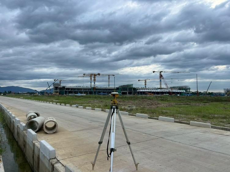
GNSS receiver on a tripod beside a road, setting project control points, SPN survey team
GNSS control point survey beside a road
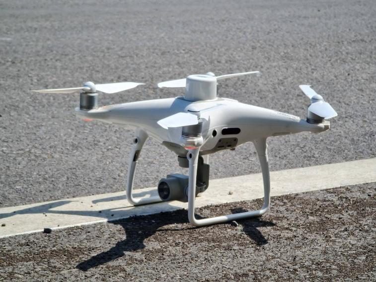
SPN survey drone (UAV) ready to fly for orthophoto and 3D terrain model
Survey drone before an aerial mapping flight
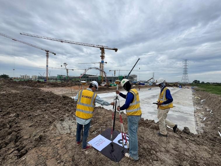
SPN team placing and surveying a ground control point (GCP) on a construction site with tower cranes
Ground control point (GCP) for drone survey
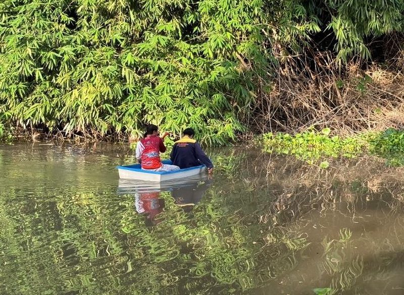
SPN survey team in a small boat measuring coordinates along a waterway and river bank
Survey by small boat along a waterway
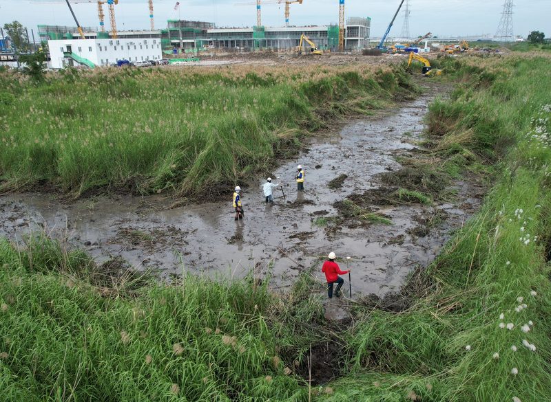
Drone view of SPN survey team collecting levels in low-lying mudflat beside a large construction project
Level survey in low-lying wet ground
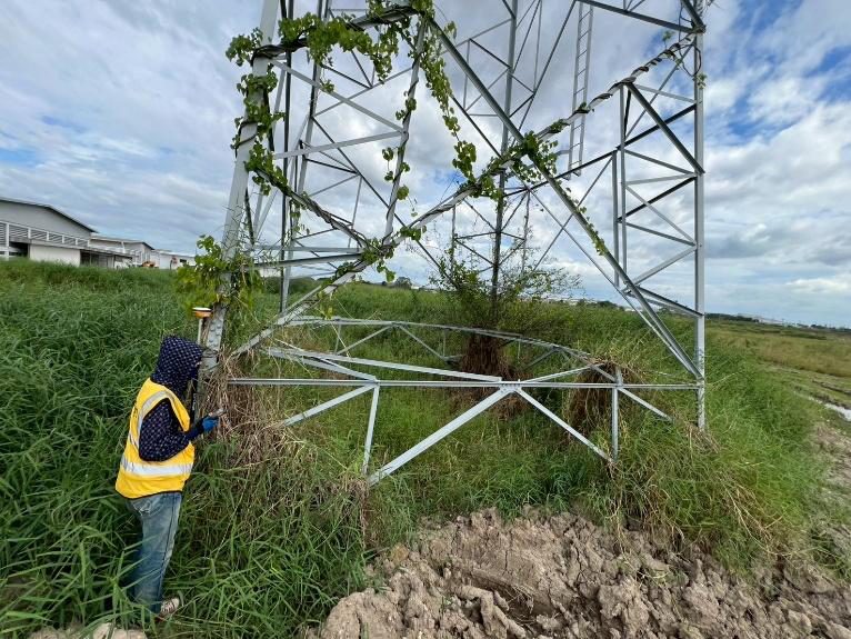
SPN surveyor recording the position of a high-voltage transmission tower (feature survey)
Feature survey of a high-voltage tower

How does a topographic survey with SPN work?

  1. Send the site boundarySend coordinates, a Google Maps link or a KMZ boundary file and tell us how the data will be used, by phone, LINE or email.
  2. Method selection and quotationAn engineer selects the method (RTK, Total Station, drone, LiDAR or echo sounder), coordinate system and resolution. You receive a free quotation within 24 hours.
  3. Set control pointsWe set control points and benchmarks, plus GCPs for drone work, and tie coordinates and levels to the project reference system.
  4. Field data collectionPoints are collected with GPS RTK (base and rover via radio or NTRIP, ±1–3 cm) and Total Station, by drone flight or by survey boat, recording X, Y, Z for every point.
  5. Processing and mappingData is processed in AutoCAD Civil 3D or ArcGIS to build a TIN model and contours at 0.25–1 m intervals, produce orthophotos or point clouds, and calculate volumes.
  6. Check and deliverResults are checked against field check points and delivered as DWG, Shapefile and PDF with a coordinate reference report, signed by a licensed engineer.

What files do you receive from a topographic survey?

  • Topographic map and contours (DWG, DXF, PDF): spot levels, contours, site boundary and structures, ready for AutoCAD / Civil 3D
  • Orthophoto (GeoTIFF): georeferenced, true-scale aerial image for overlay on drawings or GIS
  • Point cloud (LAS, LAZ): 3D points from photogrammetry or LiDAR with ground points classified
  • DSM / DTM: surface and terrain models for slope and drainage analysis
  • GIS data (SHP): boundary, utility and structure layers for ArcGIS / QGIS
  • Long profiles and cross-sections (DWG, PDF) at the required interval for roads, canals and pipelines
  • Earthwork volume report (PDF, XLSX): cut and fill or stockpile volumes with an elevation difference map
  • Control point list (XLSX, CSV): coordinates and levels with the coordinate system and datum used
  • Survey report (PDF): methods, equipment, coordinate system and accuracy checks, signed by a licensed engineer (Council of Engineers Thailand licence)

Why work with SPN in Thailand?

Coverage
Nationwide, all 77 provinces of Thailand. Office in Bang Sao Thong, Samut Prakan, near Bangkok and Suvarnabhumi Airport.
Scope
Testing, investigation and engineering design only. SPN does not take construction work, so recommendations stay independent.
Reports
Signed by a licensed civil engineer (Council of Engineers Thailand licence) and usable for Thai building permit submissions.
Language
Quotations and coordination in English or Thai.
Quotation
Free quotation within 24 hours. Send drawings, site location or TOR to info@spnth.com or LINE @spnth.

Frequently asked questions about topographic survey in Thailand

What is a topographic survey, and how is it different from a cadastral survey?
A topographic survey measures ground elevation and shape to produce contour maps for engineering and construction. A cadastral survey measures land-title boundaries and is done in Thailand by Department of Lands officers or licensed private surveyors under the Private Surveyors Act B.E. 2535 (1992). SPN does not carry out legal boundary surveys; boundary markers found on site can be shown on the map as a design reference only, not as boundary certification.
Should I use GPS RTK or Total Station?
Use GPS RTK for large open sites with clear satellite reception; it is fast and accurate to ±1–3 cm. Use Total Station in urban areas or where buildings, trees or factory structures block signals; it is accurate to ±5 mm. On most jobs SPN uses both together.
Is a drone survey accurate enough for construction?
It depends on the task. For cut and fill volumes, orthophotos and 3D models, a drone survey with GCPs gives ±3–5 cm and is much faster. Setting out and as-built surveys that need centimetre or millimetre accuracy still require GPS RTK or Total Station.
What is the difference between LiDAR and drone photogrammetry?
Photogrammetry builds point clouds and orthophotos from overlapping photos; it suits open ground and true-colour mapping at lower cost. LiDAR measures distance with a laser, and part of the laser reaches the ground through gaps in foliage, so it gives true ground levels under orchards, forest or dense vegetation where photogrammetry usually sees only tree tops. Many projects use both.
What is a bathymetric survey, and when is multibeam needed?
A bathymetric survey measures water depth and bed conditions with an echo sounder, producing depth maps and bed profiles for bridges, jetties, dredging and scour analysis. Single-beam measures along the boat track and suits canals, rivers and cross-sections. Multibeam covers a wide swath for a full high-resolution bed model, for ports, channels and bridge foundations. Side-scan sonar images the bed to find obstructions and does not measure depth directly.
How are cut and fill volumes calculated from survey data?
Two surfaces are compared (existing ground against design levels, or ground before and after earthworks) using a TIN or grid model in software such as AutoCAD Civil 3D. The result is cut and fill volumes and an elevation difference map. Volumes are in-place and exclude soil swell or shrinkage, which the designer must consider.
Which file formats and coordinate systems do you deliver?
We deliver AutoCAD DWG/DXF, PDF maps, Shapefile, orthophoto GeoTIFF, point cloud LAS/LAZ, Excel coordinate lists and a survey report. Coordinates can be WGS84 or Indian 1975, UTM Zone 47N or 48N (TM47 west of longitude 102° E, covering most of Thailand; TM48 east of it), with conversion between them. Levels are tied to MSL from nearby benchmarks or to an agreed local datum.
How long does a topographic survey take?
For a site of 1–10 rai, field work takes 1–2 days and processing and mapping take 2–3 days. A typical GPS RTK job takes about 3–8 days in total, depending on site size. Fees are priced per project from the area, method and resolution; send your site boundary for a free quotation within 24 hours.
Do drone surveys in Thailand need a permit?
Yes. Commercial drone flights in Thailand require pilot registration with CAAT (Civil Aviation Authority of Thailand), drone registration with NBTC, and extra permission in controlled areas. The SPN team holds the required registrations and coordinates flight permission for clients.