
What is a topographic survey?
A topographic survey is the measurement of coordinates (X, Y) and elevations (Z) of points across a site, processed into a map showing the highs and lows of the ground and the locations of structures, large trees, roads, fences, power poles and utilities.
A topographic map is the starting data for almost every type of design, from houses, buildings and factories to roads and drainage systems, because designers need to know the actual site conditions before setting building levels, calculating cut and fill, and laying out drainage.
Surveys in Thailand use the UTM Zone 47N/48N coordinate system, tied to benchmarks of the Royal Thai Survey Department or the Department of Lands. They can be referenced to either the Indian 1975 Datum (older mapping) or WGS84 (modern GNSS work), so the map can be used correctly together with other data.
How does a topographic survey differ from a cadastral (land boundary) survey?
A topographic survey is not a cadastral survey, and one cannot replace the other. A cadastral survey establishes the boundaries of a land plot according to the title deed and is carried out by Department of Lands officials or licensed private land surveyors. A topographic survey records elevations and details within the plot for construction design and earthwork quantity calculation, and is carried out by private survey companies.
Many project owners assume that having a title deed and knowing the boundaries is enough to start design, but in practice designers need the actual ground elevations, which are not shown in title documents — this data comes only from a topographic survey.
What deliverables does the survey produce?
- Contour Map — contour interval of 0.25–1.00 m depending on the required resolution
- Spot Elevations — ground levels at key locations, plus benchmarks on site
- Layout of structures and utilities — buildings, fences, roads, power poles, drains, canal alignments
- Digital files — AutoCAD (DWG) and PDF with reference coordinates, ready for immediate use in design
- 3D model / volume calculation — a surface model for calculating cut-and-fill volumes where filling or grading is required

What equipment is used for the survey?
There are 3 main groups of equipment, chosen according to site conditions and the required resolution.
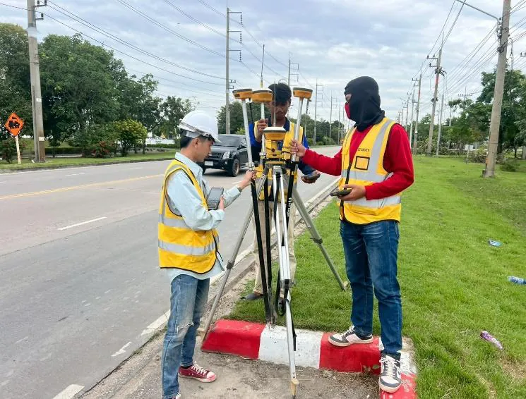
- RTK GPS/GNSS — accuracy of ±1–3 cm, fast point collection, suited to open areas
- Total Station — millimeter-level accuracy (±5 mm), suited to work requiring high resolution and points under tree cover or close to buildings
- Survey drone (UAV photogrammetry) — suited to large areas, producing aerial orthophotos and surface models, with ±3–5 cm accuracy when ground control points (GCPs) are used
For a detailed comparison, see GPS RTK vs Total Station vs Drone: which survey method to choose

What are the steps of a topographic survey?
A standard topographic survey has 5 main steps:
- Receive information and plan the work — confirm the site extent, intended use and the resolution the designer requires
- Set control points (Control Point / Benchmark) — transfer coordinates and levels from reference benchmarks into the project site
- Collect field data — survey spot levels, structures and topographic details with GPS RTK, Total Station or drone, depending on site conditions
- Process data and draft the map — check data accuracy and prepare the contour map and layout in AutoCAD
- Deliver — printed maps + DWG/PDF files with a benchmark list, certified by an engineer
How many days does a topographic survey take?
Duration depends on site size, density of detail and obstructions. Approximate figures for typical work:
← Scroll to see the full table →
| Site area | Fieldwork | Processing + mapping |
|---|---|---|
| Up to 5 rai (0.8 ha) | About 1 day | 2–3 working days |
| 5–20 rai (0.8–3.2 ha) | 1–3 days | 3–5 working days |
| 20–100 rai (3.2–16 ha) | 3–7 days | 5–10 working days |
| Route surveys | Depends on length | Assessed per project |
Sites with dense vegetation, dense buildings or difficult access will take longer than shown in this table.
How much does a topographic survey cost?
Topographic survey fees depend on 4 main factors: site area, contour resolution, obstructions on site and distance to the site. Because every project differs greatly, SPN prices each job based on the actual site — contact us for a free quote within 24 hours: call 064-746-9601 or LINE @spnth
Note: survey prices exclude travel and equipment mobilization costs, which are charged extra according to the distance to the site.
When do you need a topographic survey?
- Before designing a building/factory — set floor levels and plan the layout to suit actual site conditions
- Before filling or grading land — calculate cut-and-fill volumes accurately and control the budget
- Road and drainage design — the site gradient is needed to set flow directions (see civil engineering design services)
- Supporting project study reports — e.g. feasibility studies or environmental reports
- Checking before buying or selling land — know the actual ground levels and estimate filling costs before deciding
Most construction projects carry out the topographic survey together with soil investigation in one go, because designers need both surface data and subsurface soil layer data.
How do you choose a topographic survey company?
- ✅ An experienced team with a COE-licensed engineer supervising and certifying the work
- ✅ Calibrated equipment — GPS, Total Station and levels
- ✅ Tied to actual reference benchmarks, with the coordinate system and datum clearly stated on the map
- ✅ Complete deliverables — maps, DWG files and a benchmark list, not just PDFs
- ✅ A track record on projects of the same type as yours
Summary
A topographic survey is the starting point of good construction design, providing the elevation and site details that designers actually need. SPN Soil Engineering offers complete topographic survey services with GPS RTK, Total Station and survey drones, together with topographic, hydrographic and UAV surveys, by the same team that handles soil investigation and pile testing for SPN Group — over 20 years of experience, serving projects nationwide.