What Is GPS RTK?

GPS RTK (Real-Time Kinematic) is GNSS satellite surveying with real-time error correction: a base station sends corrections to the roving receiver (rover) via a radio link or the internet (NTRIP), giving a horizontal accuracy of about ±1–3 cm.
- Strengths: very fast point collection, covers large areas in a short time, no line of sight needed between points, and coordinates directly in a global reference system.
- Limitations: needs good satellite reception — signals are blocked under dense tree canopy or in narrow valleys, and near tall buildings signal reflections (multipath) cause errors or make it unusable.
- Best for: open areas, general topographic surveys, setting control points, and surveying road and canal alignments.
What Is a Total Station?
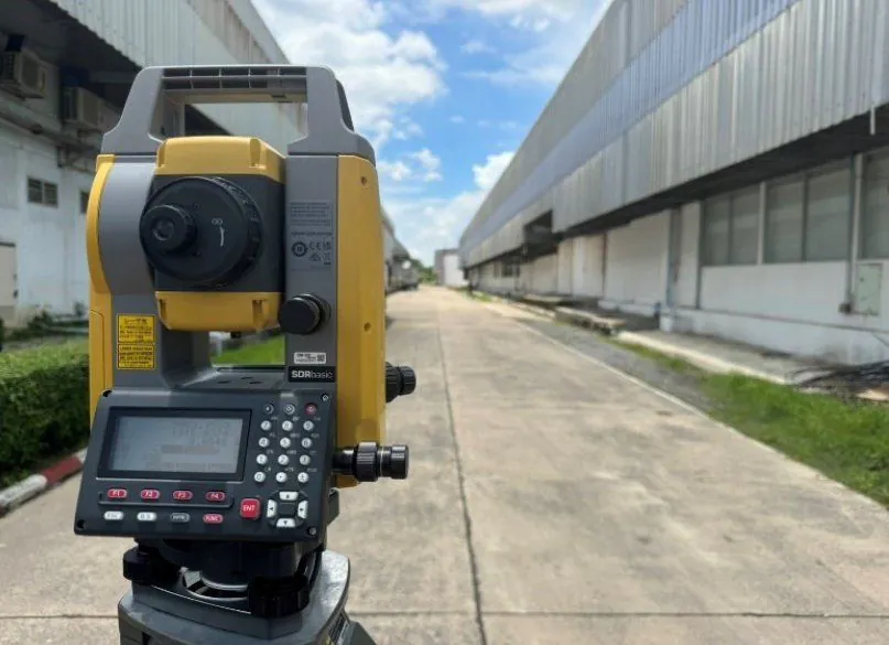
A total station is a surveying instrument that measures angles with an electronic angle-reading system and distances with light/infrared waves (EDM) in a single unit. It gives millimeter-level accuracy (about ±2–5 mm depending on the model and distance) — the most accurate of the three methods.
- Strengths: highest precision; works under tree cover, near buildings or wherever GPS cannot be used; suits both data collection and setting out (layout / stake-out).
- Limitations: needs a direct line of sight to the target, must be set up over a control point of known coordinates, and is slower than RTK over large areas.
- Best for: construction setting out, work requiring high precision, areas obstructed by trees/buildings, and structural movement monitoring together with geotechnical and structural instrumentation.
What Is a Drone Survey?

A drone survey (UAV photogrammetry) is flying overlapping aerial photos and processing them into a georeferenced orthophoto and a 3D surface model (DSM/DTM). With ground control points (GCPs) surveyed by GPS RTK, accuracy is about ±3–5 cm.
- Strengths: covers large areas fastest, provides real imagery to accompany the map, shows the whole project at a glance, and is well suited to stockpile volume calculation.
- Limitations: sees only the top surface — ground under dense vegetation will be inaccurate; drones must be registered with CAAT and the NBTC, and flight permits are needed in controlled zones; weather affects operations.
- Best for: areas of 50 rai (8 ha) or more, quarries/borrow pits, construction progress monitoring, and project master plans.

Comparison Table: GPS RTK vs Total Station vs Drone
← Scroll to see the full table →
| Topic | GPS RTK | Total Station | Drone (UAV) |
|---|---|---|---|
| Accuracy | ±1–3 cm | ±2–5 mm | ±3–5 cm (with GCPs) |
| Speed | Fast | Medium | Fastest over large areas |
| Suitable area | Open, small to medium | Any condition, high detail | Large, 50 rai (8 ha) or more |
| Main limitation | Unusable under trees/near buildings | Needs line of sight; slow over large areas | Cannot see ground under vegetation; flight permit needed |
| Key output | Coordinates directly in a global system | High-precision layout work | Orthophoto + 3D model |
So Which One Should You Choose?
- Vacant land/houses up to 10–20 rai (1.6–3.2 ha), open area → GPS RTK is the most cost-effective and fastest
- Construction setting out, positioning piles and buildings → Total station, because millimeter-level accuracy is required
- Areas with many trees/obstructions → Total station for the detail, with control points set by GPS in open spots
- Large projects, quarries, borrow pits, master plans → Drone + GCPs gives both a map and real imagery
- Measuring soil/material stockpile volumes → Drone processing computes volumes quickly
Professional survey teams do not pick a single instrument; they combine them to suit the site — for example, using GPS RTK to set control points and GCPs → flying a drone to capture the whole area → using a total station to pick up points under tree cover and details the drone cannot see. This gives both speed and accuracy.
Does Survey Pricing Differ by Method?
Fees depend on the size of the area, the required level of detail and the distance to the site more than on the instrument type, because the survey team will choose the most cost-effective method for the site anyway — contact us for a free quotation within 24 hours: call 064-746-9601 or LINE @spnth
Note: survey prices exclude travel and equipment mobilization, which are charged extra according to the distance to the site.

Summary
GPS RTK is fast and cost-effective in open areas, a total station is the most accurate and works in any condition, and a drone covers large areas quickly with real imagery. SPN Soil Engineering has all three systems, and our engineers will choose the right method for your site so you don't have to guess. See service details on the topographic survey page, or read the basics in What is a topographic survey?