Why is over-water soil boring important?
Many construction projects in Thailand are located in or near water, including river bridges, ports, oil and LPG terminals, offshore projects and dams. All of them need data on the soil layers beneath the water to design foundations, and conventional land drilling methods cannot be used. (Read the basics in why soil investigation is needed before construction and see the scope of SPN's soil investigation services)
The model below shows the components of the most common mid-river drilling setup: a floating raft held by multiple anchors, steel casing extending from the raft through the water into the riverbed soil, and a service boat that shuttles the crew and samples.
Soil under water poses special challenges: there may be 5-30 m of water or more above the ground surface, the equipment must be mounted on a floating base, and water must be kept out of the borehole at all times.
4 types of platform for over-water soil boring
1. Floating raft
This is the most economical and most widely used method, suited to calm water such as rivers, canals and lakes.
- Steel or plastic floats are assembled into a floating base.
- Held by 4 anchors, or by spud legs driven into the seabed.
- A skid-mounted drilling rig sits on the raft.
- Suitable for water depths of 2-15 m and waves under 1 m.
2. Barge-mounted
Used for work at sea with waves and strong currents:
- A 20-40 m barge with 3-4 spud legs.
- Spud legs are driven into the seabed to hold the barge firmly.
- Crawler-mounted or skid-mounted drilling rig.
- Suitable for water depths of 5-50 m and waves up to 2-3 m.
3. Jack-up Platform
For offshore work that requires high stability:
- The platform can be raised clear of the water by hydraulic jacks.
- 3 extra-long spud legs allow drilling in deep water.
- Suitable for water depths of 10-80 m.
- Rental cost is very high (💰💰💰💰) compared with other methods.
4. Drilling vessel
For deep-sea work at petroleum-industry level — rarely used in civil engineering.
The section below summarizes the layout of river boring work, from boreholes on both banks to holes in mid-river, and compares the water depth range suited to each type of drilling platform.
Case Study 1: River soil boring for a bridge over the Nakhon Chai Si River, Nakhon Chai Si District, Nakhon Pathom
A 400 m bridge project over the Nakhon Chai Si River in Nakhon Chai Si District, Nakhon Pathom. A total of 6 boreholes were drilled (BH-1 to BH-6): 3 in mid-river (BH-2, BH-3, BH-4) and 3 on the two banks (BH-1, BH-5, BH-6), each about 40.95 m deep. The work was carried out in May 2022.
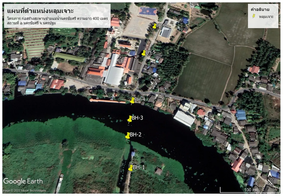
Problems encountered
- 3 holes in mid-river: BH-2, BH-3 and BH-4 had to be drilled from a floating platform in the middle of the river, with equipment and crew transported by boat.
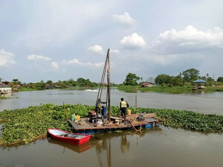
- Current and water hyacinth: the current pushed the raft out of position, and dense water hyacinth obstructed raft placement and anchoring.
- Soft clay below the riverbed: the upper layers are very soft to medium stiff clay (Very Soft–Medium Stiff CLAY), so the borehole walls collapse easily and water/sediment flows into the hole.
- Dense sand deep in mid-river: in the middle of the river (BH-3) there is an especially thick stiff clay layer, like an old channel, so the dense sand bearing layer lies deeper than at the banks.
SPN's solutions
- Used a floating raft with a tripod rig, wash boring, and SPT sampling every ~1.5 m in accordance with ASTM D1586.
- Held the raft with anchors/ropes at multiple points against the current, positioned the raft during slack water, and cleared a path through the water hyacinth before setting up.
- Installed steel casing through the soft clay to prevent hole collapse and keep water/sediment out of the hole.
- Took undisturbed clay samples (Shelby tube) for laboratory strength testing.
- Used a service boat to shuttle the crew and carry samples ashore.
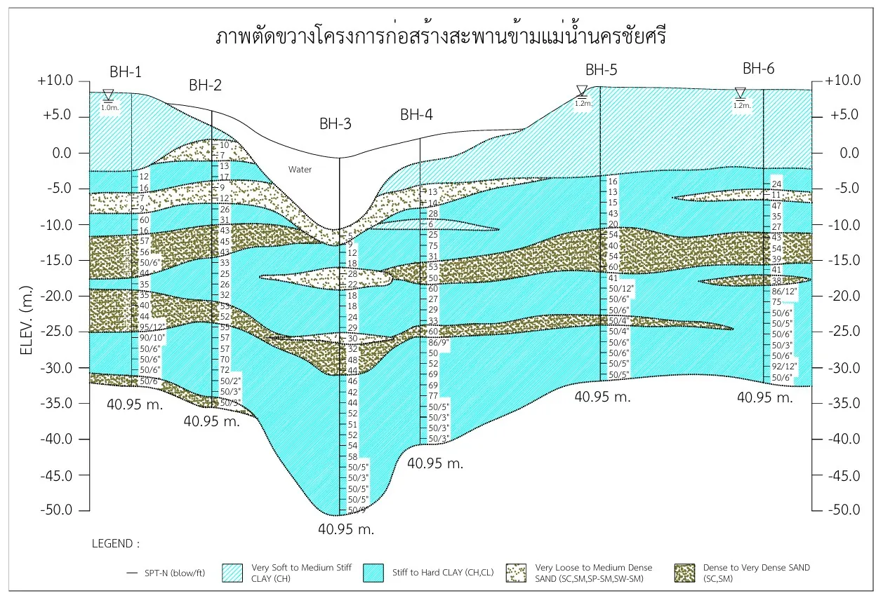
Soil profile encountered
The soil profile shows the following sequence from top to bottom: very soft to medium stiff clay (Very Soft–Medium Stiff CLAY, CH), underlain by stiff to hard clay (Stiff–Hard CLAY, CH/CL) with lenses of very loose to medium dense sand (Very Loose–Medium Dense SAND), and at the bottom a dense to very dense sand layer (Dense–Very Dense SAND) with SPT-N values high enough to reach refusal (e.g. 50/6", 86/9", 92/12").
Result
All 6 boreholes were completed, each about 40.95 m deep, reaching the dense to very dense sand bearing layer. The SPT-N data and soil samples were used in designing the bored pile foundations of the bridge piers, especially the mid-river piers where the bearing layer lies deeper than at the banks.
Case Study 2: Soil boring in the Srinagarind Dam reservoir — drilling through limestone, Kanchanaburi
An environmental impact assessment (EIA) study for a bridge across the Srinagarind Dam reservoir in Dan Mae Chalaep Subdistrict, Si Sawat District, Kanchanaburi. A total of 3 soil–rock boreholes were drilled (SB-01, SB-02, SB-03): SB-02 in the middle of the reservoir, and SB-01 and SB-03 near the shore. The work was carried out in December 2015.

Problems specific to reservoir work
- Deep, wide water in the reservoir: SB-02 is in the middle of the reservoir, so a large steel pontoon/raft had to be assembled to float the drilling rig out into open water.
- Fluctuating reservoir level: the water level depends on the dam's water management, so allowances had to be made and the pontoon kept securely anchored throughout the work.
- Remote forest/mountain area: transporting tools and equipment to the drilling locations was difficult.
- Hard rock at very shallow depth: the very dense sand reached refusal quickly (e.g. 50/3", 50/5"), so drilling could not continue with SPT and had to switch to rock coring.
- "Float rock" encountered: at SB-03, which could be mistaken for bedrock.
SPN's approach
- Assembled a large steel pontoon/raft in the middle of the reservoir, held by multiple anchors, with the drilling rig and rock coring equipment installed on the pontoon.
- The crew wore life jackets, with a small boat standing by for transfers.
- When SPT reached refusal in the very dense sand, switched to rock coring with a core barrel and assessed rock quality by RQD (Rock Quality Designation).
- At SB-03, drilled through the float rock to prove it was a loose boulder rather than bedrock, then continued drilling into continuous limestone.

Soil–rock profile encountered
The key feature of this job is that bedrock is very shallow, completely unlike Case Study 1. The top is a thin layer of very dense sand (Very Dense SAND, SM/SC) (with hard clay in places at SB-02), followed within only a few meters by bedrock of quartzite and limestone. Rock quality measured by RQD varies widely (e.g. 10–99%), indicating that the limestone is fractured and has cavities (limestone/karst terrain).


Result
All 3 boreholes were completed, drilling through the dense sand and coring rock down to the shallow bedrock (limestone/quartzite). The rock layer data, RQD values and float rock location were used in the environmental impact assessment report and in designing the bridge pier foundations, which must also take account of fractures and cavities in the limestone.
Case Study 3: Coastal soil investigation — soft marine clay, Mueang Samut Sakhon District, Samut Sakhon
A project in a coastal area of Bang Krachao Subdistrict, Mueang Samut Sakhon District, Samut Sakhon. Four boreholes were drilled (BH-1 to BH-4): BH-1 on land, and BH-2, BH-3 and BH-4 in the water on the coastal mudflat. The site lies in the soft marine clay zone of the upper Gulf of Thailand.

Problems encountered
- Very thick soft marine clay: the upper layer is very soft to medium stiff clay (Very Soft–Medium Stiff CLAY) about 15 m thick, so the borehole walls collapse easily and sampling is difficult.
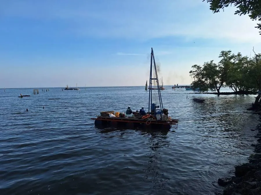
- 3 holes in the water: BH-2, BH-3 and BH-4 are on the coastal mudflat and can be reached by raft only at high tide.
- Coastal tides: the mudflat is exposed at low tide, grounding the raft, so work must be planned around the tide table.
- Coastal obstructions: fishing stakes, pontoons and soft mud make raft placement and anchoring difficult.
SPN's approach
- Used a floating raft with a tripod rig, wash boring, and SPT sampling in accordance with ASTM D1586.
- Planned the over-water holes around the tide table, drilling when the tide was high enough for the raft to float and move in and out.
- Installed steel casing through the soft clay to prevent hole collapse and keep mud out of the hole.
- Took undisturbed clay samples (Shelby tube) for laboratory shear strength (Su) testing.
- Drilled BH-1 on land with a standard rig to compare the soil sequence with the over-water holes.
Soil profile encountered
The soil profile shows the following sequence from top to bottom: fill/topsoil at the land hole, over very soft to medium stiff clay (Very Soft–Medium Stiff CLAY, CH) about 15 m thick, followed by stiff to hard clay (Stiff–Hard CLAY, CH/CL), and at the bottom dense to very dense sand (Dense–Very Dense SAND, SP-SM/SM/SC) below about 20 m — a typical soft marine clay profile of the upper Gulf of Thailand lowlands.
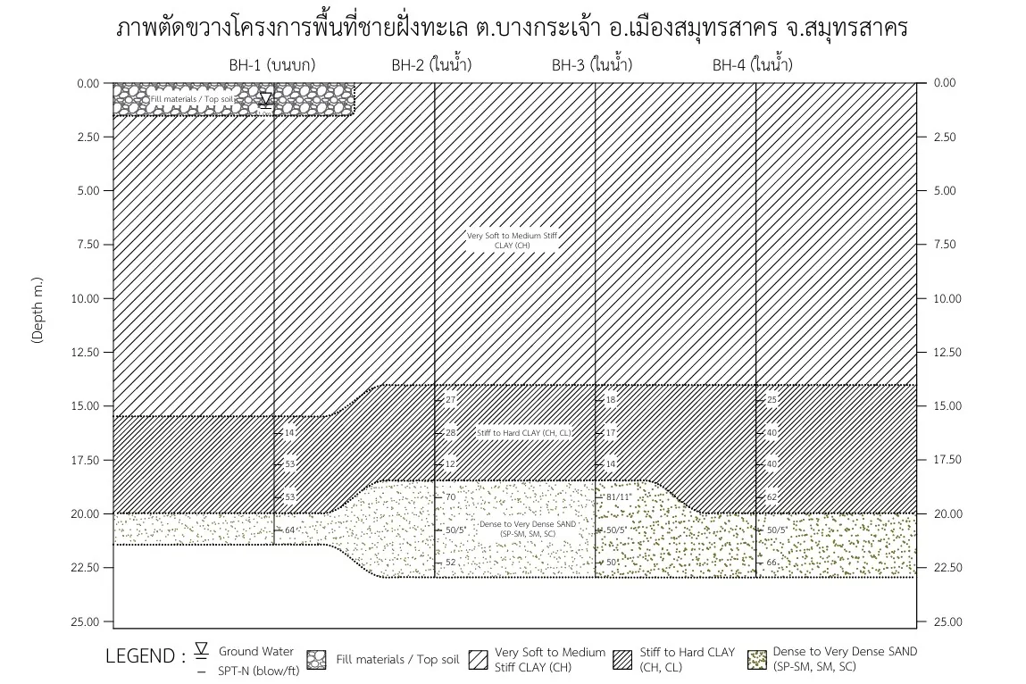
Result
All 4 boreholes were completed to about 22–23 m deep, reaching the dense–very dense sand bearing layer. The soft clay thickness and shear strength data were used in foundation design, where in principle pile tips should pass through the soft clay into the dense sand to avoid the large settlement of the soft marine clay.
Cost comparison: land vs over-water soil boring
← Scroll to see the full table →
| Type | Cost level* | Time | Challenges |
|---|---|---|---|
| On land, typical | 💰 | 1-2 days | Low |
| River, water depth <5 m | 💰💰 | 3-5 days | Medium |
| River, water depth 5-15 m | 💰💰💰 | 5-7 days | High |
| Nearshore sea | 💰💰💰💰 | 5-10 days | Very high |
| Offshore, water depth 20+ m | 💰💰💰💰💰 | 7-14 days | Max |
* 💰 = relative cost level (not a fixed price) — more symbols mean higher cost, due to rafts/boats, floating equipment and longer working time. Actual costs depend on each project's conditions and exclude travel and equipment mobilization, which are charged according to the site distance — for actual prices, please request a free quotation within 24 hours. (Compare land-based prices in soil boring prices in 2026)
Classic problems in over-water soil boring
1. Hole collapse
Caused by water pushing sediment into the hole. The fix is to support the borehole wall with steel casing or bentonite/polymer mud.
2. Disturbed samples
Sampling under water often yields samples that are more disturbed than on land, so lab test results do not reflect actual conditions. The fix is to use a thin-walled Shelby tube or piston sampler.
3. Difficult borehole positioning
In open sea, DGPS or RTK GPS is needed to fix positions accurately to ±0.5 m.
4. Weather
Strong wind, big waves and rain can stop work, so allow 20-30% extra time for non-working days.
Relevant standards
- ASTM D4823: Core Sampling Submerged, Unconsolidated Sediments
- ISO 19901-8: Offshore Structures — Part 8: Marine Soil Investigations
- BSI BS EN ISO 22475-1: Geotechnical Investigation and Testing
- API RP 2A: Offshore Platforms Foundation Design
For standards for soil investigation on land, read more in ASTM standards for soil investigation and testing.
Summary
Soil investigation over water and at sea requires experience, specialized equipment and detailed planning. It costs 3-5 times more than land work but is essential for projects located in water. Results are summarized in a boring log report, just as for land work (see how to read one in the boring log guide).
SPN Soil Engineering has more than 20 years of soil investigation experience, including over-water boring in rivers, dam reservoirs and coastal areas, as shown in the case studies in this article. Contact us for a free consultation on your project.