Most of SPN's instrumentation work is on the soft-clay plains of central Thailand, but inclinometers are equally suited to slopes and embankments and are the main tool for finding the plane on which a slope is moving. This case study draws on the inclinometer casing installation at the Kraseaw Hydropower project in Dan Chang District, Suphan Buri. The site is in the foothills, so the ground is completely different from Bangkok. For the basic principles of the instrument, see What is an inclinometer?, which has a section dedicated to slopes.
What Was the Brief for This Job?
The brief was to find out whether the slope at the construction site was moving, at what depth, and how the rate of movement changed in the rainy season. The project involves construction on ground with slopes and cut-and-grade earthworks in the foothills. SPN was responsible for drilling borehole BH-1, installing the inclinometer casing and taking the baseline readings. The same borehole was used to log the soil layers during drilling.
Unlike Bangkok, the ground here is colluvium (hillslope sediment) over weathered rock and bedrock, and layer thicknesses change rapidly over short distances. The casing depth therefore cannot be fixed from the drawings; it has to be decided from the soil and rock actually recovered from the hole. For the principles of slope stability and why slopes move, see Slope stability and F.S. and What causes landslides and how to prevent them.
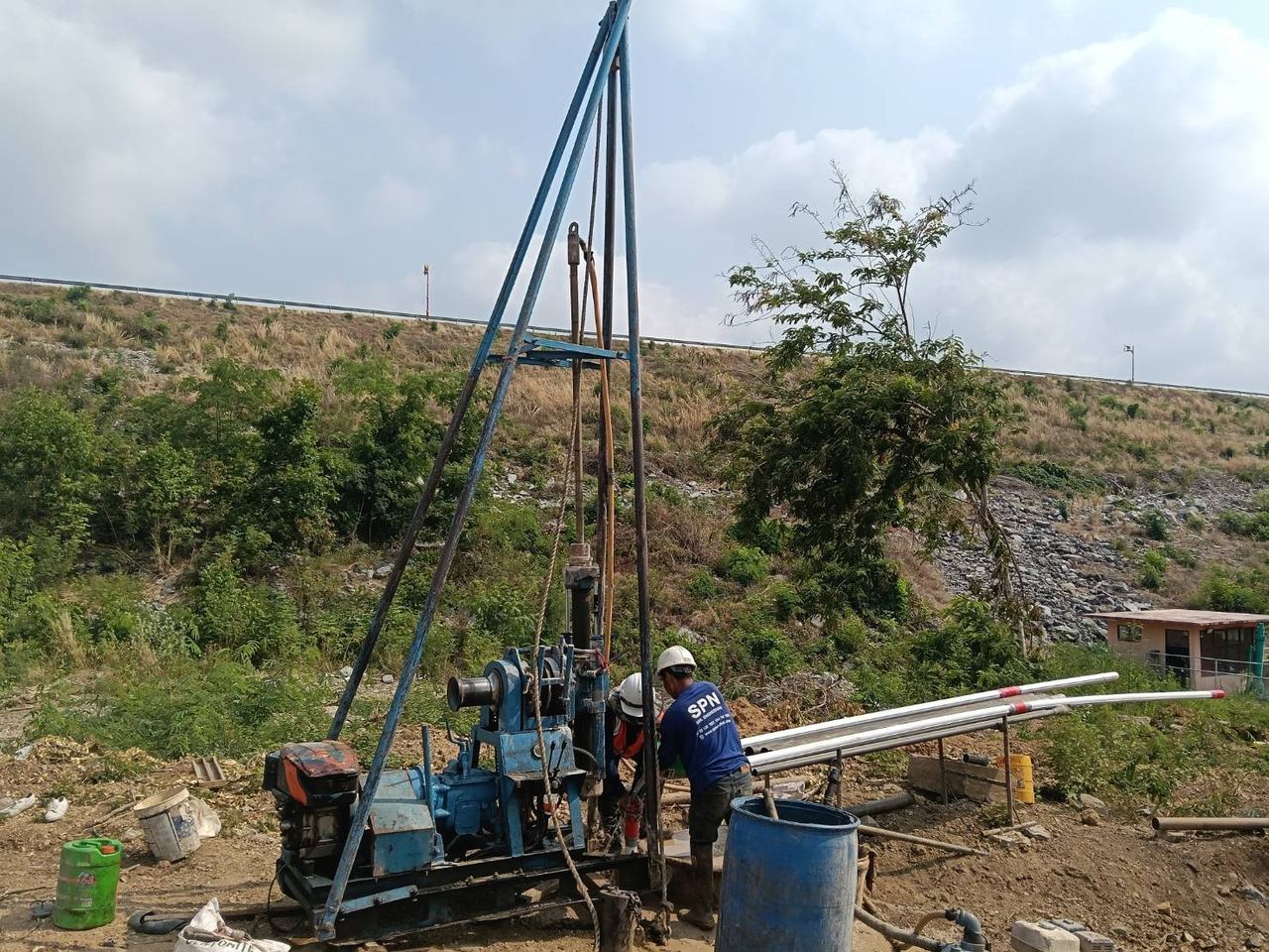
How does installation in hillside ground differ from soft clay?
Installing an inclinometer in hillside ground differs from soft clay in that the "non-moving layer" is dense weathered rock or bedrock, and its level must be confirmed by actual drilling. The principle is the same as any job: the casing tip must be embedded in a layer that does not move. On a slope, this means the layer below every possible slip surface, so the casing must be drilled deep enough into it, not just touching it. If the actual slip surface is deeper than the casing tip, the whole profile shifts and you cannot tell where the ground is moving.
There are three steps that differ from soft-clay work. The measurement method follows ASTM D6230, as for deep excavations.
- Drilling: change the drilling method when passing from soil into weathered rock, and record the level of each layer change in detail (see the guidance in Rock coring).
- Groove alignment: orient the A-axis downslope, in the expected direction of movement, not perpendicular to a wall line as in a deep excavation.
- Backfilling: in fractured weathered rock, watch for grout loss, because it leaves the casing poorly coupled to the ground and the readings will not reflect actual movement.
The 3D view below is a conceptual illustration of the BH-1 location on a foothill slope. It shows the casing passing through the colluvium and the possible slip surface, with the tip embedded in rock. The part of the casing above the slip surface is displaced downslope as the soil mass moves, creating a kink at the shear zone. This is not a project drawing or actual monitoring data.
How are readings taken, and how do they differ from deep excavations?
On slopes, readings are scheduled by time and season and monitoring often runs for a year or more, unlike deep excavations, where readings follow the excavation stages and end when the underground structure is complete. The baseline is read several times after installation, followed by routine readings, with frequency increased in the rainy season or after prolonged heavy rain, because infiltrating water directly accelerates slope movement. Where continuous data are needed, in-place inclinometer probes can be installed and connected to a datalogger with automatic alarms. See the comparison in Manual vs Automatic Monitoring.
← Scroll to see the full table →
| Topic | Slope (this case) | Deep excavation in soft clay |
|---|---|---|
| Reading schedule | By time and season, more often in the rainy season | By excavation and strut installation stages |
| Monitoring duration | Often a year or more, through the rainy season | Ends when the underground structure is complete |
| A-axis direction | Downslope | Perpendicular to the wall line |
| Plot shape | Kinks at the shear zone; the soil mass above moves almost as a single block | Bulges in the middle because the wall is restrained at top and bottom |
How are results interpreted, and what does the kink tell you?
The kink in the profile is the level of the shear zone or slip surface, and it is the first thing an engineer looks for on a slope. The telltale sign is a soil mass above a certain level moving almost uniformly as a block, with values dropping abruptly over a short depth range. Knowing this level changes every decision, because stabilization measures — drainage, regrading or earth-retaining structures — must be designed to cut through this plane to be effective.
The other thing to watch is the rate of movement, from the plot of maximum value versus time. Many slopes creep slowly each rainy season and stop in the dry season, which is acceptable to a degree. But if the rate keeps accelerating within the same rainy season without slowing, that is a warning sign of failure that must be reported immediately. Alarm levels for each project are set by the design engineer from a site-specific stability analysis; there is no universal figure.
What are the lessons from the Dan Chang project?
There are three lessons from Dan Chang: casing depth is decided on site, a single hole tells you about only one location, and mountain sites need access planned from the outset.
- Casing depth is decided on site. The weathered rock level actually encountered determines the casing length, so the drilling team must bring spare casing and be empowered to decide on the spot together with the design engineer.
- A single inclinometer tells you about only one point. On slopes where the shape of the slip surface across the whole slope is needed, place at least 2–3 holes in a line up and down the slope, ideally paired with piezometers to link movement to water levels (see What is a piezometer?). The number and locations are as specified by the design engineer.
- Mountain sites are about access. Access routes to the hole in the rainy season, safety of the reading team, and protecting the casing top from runoff must be planned from the time the hole location is chosen.
For another type of slope and hillside-cut project that SPN designed and monitored, see Case study: retaining wall for a hillside cut slope. For inclinometers in a soft-clay deep excavation, where the plot pattern is completely different, compare Case Study: Inclinometer in a deep excavation, Bang Phli. If you are unsure whether your project needs instrumentation, see When is instrumentation required?
Fees for instrument installation and reading depend on the type and number of instruments, installation depth and reading frequency, so they are estimated per project. Contact us for a free quotation within 24 hours. Prices exclude travel and equipment mobilization costs, which are charged extra depending on the distance to site.
Project details and photographs are from an actual SPN installation. All graphs in this article are conceptual examples showing result patterns typical of similar work, not measured values from this project, because the monitoring data belongs to the project owner. Alarm levels, instrument locations and reading frequencies must be set for each job by the design engineer based on its specific conditions.